Roman Baths of Varna
257 km away
The Roman Baths of Varna are the remains of a public bath complex built in the late 2nd century AD in Odessos, the…
1 ticket or tour
Ancient Monument · Roman · Turkey
The Aqueduct of Valens is the great two-tiered stone and brick bridge that strides across central Istanbul, completed in AD 373 to bring water to Constantinople. About 921 metres of it survive in the Fatih district, with traffic on Ataturk Boulevard passing under its arches. It was the final section of one of the longest water systems of the ancient world.
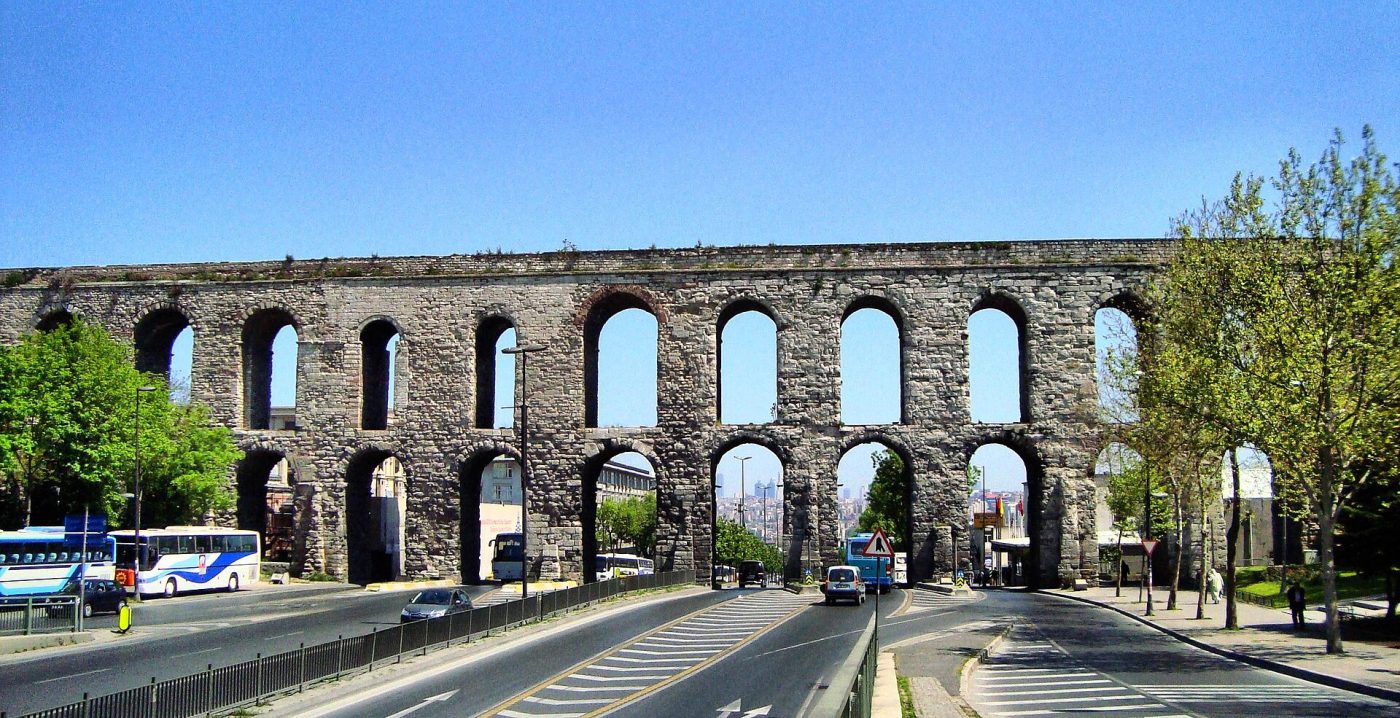
Photo: HALUK COMERTEL, CC BY 3.0
Nothing for the aqueduct alone is sold online, and there is no ticket. The aqueduct is a city monument that you see from the streets around it: from Ataturk Boulevard, where the arches span the road, and from Sarachane Park and the side streets to the north and south. Walking on top is forbidden.
Most visitors see it on the way to other sights. Walking tours of the old city sometimes include it as a stop between the Grand Bazaar and the Suleymaniye or the Fatih Mosque, and food tours often pass under it to the market beneath its arches. Bus tours of Istanbul usually just drive along the boulevard. Ask the guide of your old city walk whether it is on the route, or plan your own.
The best way is on foot. Start at the Sehzade Mosque, walk along the arches through the park, cross the boulevard and continue towards the Fatih Mosque, with a stop for lunch in the market streets. This takes about an hour and gives you views of both tiers of arches. For most visitors, a self-guided walk combined with a visit to the Suleymaniye is the sensible plan.
Start where the aqueduct crosses Ataturk Boulevard, the busiest point and the best place to understand its scale. The double tier of arches rises close to 30 metres above the road at the deepest part of the valley. Watch buses and cars pass beneath, and look at the mixture of stone blocks and brick bands in the piers.
Walk along the arches on the eastern side, through the park around Sarachane. From here you see the aqueduct against the domes of the Sehzade Mosque, one of the classic views of the old city. The park has benches and shade, and the aqueduct stands clear of surrounding buildings, showing its full length and the repairs of different periods.
Live prices from GetYourGuide for tickets and tours that include this site. Free cancellation on most of them.
On the western side of the boulevard, a lively street market and food quarter, known as the Women's Market, spreads around the arches. It is famous for dishes from south-eastern Turkey, such as slow-roasted lamb. Stop here for lunch and look at the arches rising above the stalls, with small shops built into the spaces between the piers.
Follow the aqueduct westwards up the hill towards the Fatih Mosque, built on the site of the Byzantine Church of the Holy Apostles. Along the way the arches run between houses and streets, and you see how the structure carried water across the valley between the third and fourth hills. It is quieter here, with fewer cars.
At the eastern end, near the Sehzade Mosque, look for the joins and repaired sections, where Byzantine and Ottoman builders restored the aqueduct after earthquakes and wars. Some piers and arches show clear signs of later rebuilding in different stone, and the mixture of styles tells the story of more than a thousand years of use.
The aqueduct was begun under Constantius II and completed in AD 373 under the emperor Valens, whose name it bears, to bring water to the new capital of Constantinople. It was the last section of a vast system of channels and bridges stretching from springs in Thrace, extended in the 5th century to reach over 700 km, the longest of antiquity. The water fed cisterns and reservoirs across the city. The Avars cut it in 626, and Constantine V repaired it after a drought in 758. Later emperors maintained it until the 12th century. After 1453 the Ottomans restored and extended it, and it supplied water into the modern era. Today about 921 metres survive.
The aqueduct is in the Fatih district, on the historic peninsula of Istanbul. The easiest way is the M2 metro to Vezneciler, then a walk of about 5 minutes west past the Sehzade Mosque. The T1 tram stops at Beyazit and Laleli, about 10 minutes away on foot. From Sultanahmet, the walk via the Grand Bazaar takes about 30 minutes. Many buses run along Ataturk Boulevard. Istanbul Airport is about an hour away by metro or taxi, and Sabiha Gokcen about an hour and a quarter by car. Driving is not advisable in the old city.
Do not climb the aqueduct or walk on top; it is forbidden and unsafe. Take care crossing Ataturk Boulevard, using the crossings and lights. Drones are restricted in central Istanbul. Dress modestly if you visit the nearby mosques, with shoulders and knees covered, and women should bring a scarf. The market area has many cafes and restaurants; toilets are easiest to find in the mosques or cafes.
The aqueduct is visible at any time, but the streets around it are busy with traffic and shoppers from mid-morning onwards. Early morning is the quietest time, with soft light on the arches and fewer cars. Late afternoon also works well, especially for photographs from the park with the sun behind you.
The best months are April to June and September to October, when the weather in Istanbul is mild and walking is pleasant. July and August are hot and humid, so walk early or late. Winter is cool and rainy, with occasional snow, but the aqueduct looks striking in winter light. The market under the arches is busiest at lunchtime, and on Fridays the area around the mosques is crowded at midday prayer. Allow 30 minutes to an hour for the walk.
The Sehzade Mosque is next to the aqueduct, and the Suleymaniye Mosque is about 15 minutes' walk east. The Grand Bazaar is about 20 minutes away, and the Fatih Mosque is 10 minutes west. The Zeyrek Mosque, the former Pantokrator monastery, is a short walk north.
257 km away
The Roman Baths of Varna are the remains of a public bath complex built in the late 2nd century AD in Odessos, the…
1 ticket or tour
258 km away
Troy is the mound of Hisarlik near the Dardanelles, where nine cities were built one on top of another from about 3000…
24 tickets & tours
258 km away
The Pergamon Acropolis is the hilltop capital of the Attalid kings, rising 335 metres above modern Bergama in western…
9 tickets & tours
| Hours | Visible at all times from the streets and park |
|---|---|
| Closed | Open daily |
| Entry fee | Free |
| Time needed | 30 minutes to an hour |
| Best time | Early morning or late afternoon; April to June and September to October |
| Booking | No booking needed |
| Access | Viewed from busy streets and a park; level at the boulevard, steep side streets |
| Getting there | A 5-minute walk from Vezneciler metro on the M2 line, or 10 minutes from the Beyazit tram stop |
| Founded | AD 368 (completed AD 368, inaugurated 373) |
| Civilisation | Roman |
| UNESCO | Historic Areas of Istanbul |
| Checked | October 2026 |
Visible at all times from the streets and park. Open daily.
Entry fee: Free.
Allow 30 minutes to an hour for Aqueduct of Valens.
No booking needed.
Yes. GetYourGuide sells tickets and guided tours whose route includes Aqueduct of Valens; live prices are shown on this page.
Early morning or late afternoon; April to June and September to October.
A 5-minute walk from Vezneciler metro on the M2 line, or 10 minutes from the Beyazit tram stop.
Viewed from busy streets and a park; level at the boulevard, steep side streets.
Worth it for a free, close look at a working Roman aqueduct, in a lively part of the old city away from the main sights. Skip a separate trip if time is short: you can see it from a taxi on the way to the Suleymaniye or Fatih mosques.
Aqueduct of Valens dates from AD 368 (completed AD 368, inaugurated 373).
Yes. Aqueduct of Valens is part of the UNESCO World Heritage Site Historic Areas of Istanbul.