Ancient City · Andean · Colombia
Ciudad Perdida (Lost City)
Ciudad Perdida, called Teyuna by the indigenous peoples of the Sierra Nevada de Santa Marta, is a Tairona city founded around AD 800 in the Colombian jungle. Its 169 stone terraces lie at the end of a four to five day trek with 1,200 steps for the final climb, and the only way in is with a licensed guide.
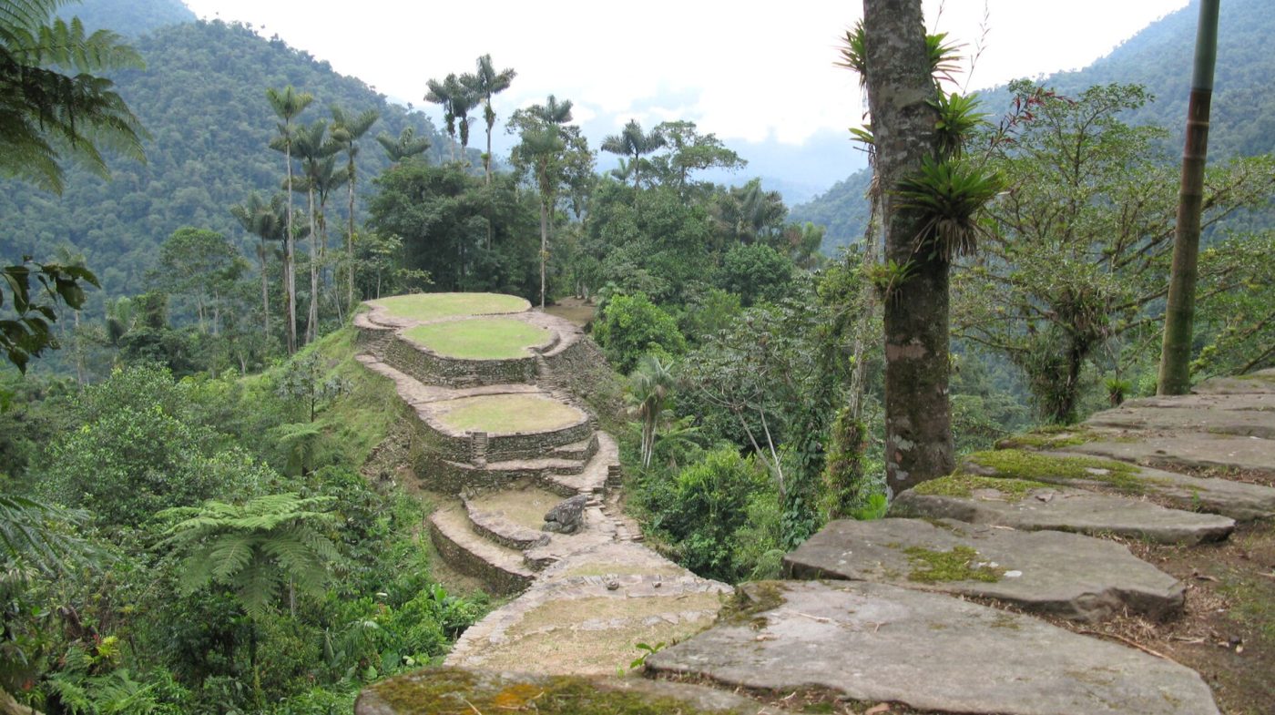
Photo: Gavin Rough from Waterloo, Canada, CC BY 2.0
Ciudad Perdida (Lost City) tickets: which one for you
Our pick for each kind of visit, with live dates and prices from GetYourGuide. Free cancellation on most.
Best for: Most trekkers, fit and unhurried
The standard four-day schedule, with transport from Santa Marta, a licensed guide, meals and camps, at a pace that leaves time to swim in the rivers.
- More time with indigenous culture: Santa marta 5 day lost city trek with indigenous village Five days instead of four, with shorter daily walks and a visit to a Wiwa or Kogi village, which makes the trek easier on the legs and less rushed.
- Very fit walkers short of time: Lost city express discover colombia s hidden gem in 3 days A compressed three-day version starting near Minca, with long, hard days on the trail; only for people used to hiking in heat and humidity.
Tickets and tours: all the options
Independent visits are not allowed. Every trip is a guided trek sold by one of a small number of agencies licensed by the authorities in agreement with the indigenous communities, and the price is regulated, with little difference between operators. It includes transport from Santa Marta to the trailhead, the entrance fee, an indigenous or local guide, a cook, all meals, drinking water and beds or hammocks with mosquito nets in shared camps. Mules carry food, but you carry your own bag. Insurance and tips are usually extra.
The main choice is length. The classic route takes four days, two in and two out on much the same path. A five-day version shortens each stage and often adds a stop at an indigenous village, while a three-day option compresses the route into very long days. A few agencies offer an alternative trail from a different starting point, and some depart from Minca rather than Santa Marta. Group sizes vary, so ask how many people share the guide and whether an English-speaking translator joins the group.
For most people the four-day trek is the right choice. Pick five days if you are not a regular hiker or want time with the communities, and three only if you are very fit.
What to see at Ciudad Perdida (Lost City)
The trail through the Sierra
The walk itself is half the experience. From El Mamey the path climbs over cleared hills with long views, then drops into forest along the Buritaca River, passing coffee and cacao farms. Expect swimming holes at the camps, several river crossings on foot or by small bridges, and stretches of red mud after rain. The second day is the longest.
The 1,200 stone steps
On the third morning groups cross the Buritaca and start up a stairway of about 1,200 narrow stone steps set into the hillside by the Tairona. The climb takes half an hour or more and is slippery when wet, but the forest shade keeps it cool. At the top you reach the first terraces and the stone paths that link them.
11 tickets and tours for Ciudad Perdida (Lost City)
Live dates and prices from GetYourGuide. Free cancellation on most tickets.
Central terraces
The heart of the city is a ridge of large oval terraces, faced with river stones, where wooden houses with thatched roofs once stood. Several platforms are linked by stairways and paved paths and form the well-known view of grassy circles stepping down the ridge, framed by forest. Soldiers usually keep a post here and the terraces are kept clear by local workers.
Ceremonial area
Higher up, a group of terraces and circles is still used by Kogi and other indigenous leaders for ceremonies. Some are closed to visitors, and guides explain which ones may be crossed. Look for stones carved with lines and hollows that local guides interpret as maps of the region, and for the remains of water channels that drained heavy rain off the platforms.
Lower terraces and the return
On the way down groups usually pass a cluster of smaller terraces and the start of other paved paths, a reminder that the city was one centre of a wider network of settlements, many still unexcavated. The descent of the steps is harder on the knees than the climb, and most groups are back at camp by lunchtime before walking out over two days.
A short history
The Tairona built Teyuna around AD 800, some six centuries before Machu Picchu, as a political and craft centre in the Buritaca valley. Between 2,000 and 8,000 people may have lived on its terraces. The Tairona left in the 16th century after decades of trade and conflict with the Spanish. Kogi, Wiwa and Arhuaco communities, their descendants, kept the site secret, and the outside world learnt of it only in 1972, when treasure hunters found it and gold objects reached the black market. The Colombian Institute of Anthropology reached it in 1976 and restored it until 1982. Tourism stopped after a kidnapping of foreign trekkers in 2003 and resumed in 2005. The site is on Colombia's tentative UNESCO list.
Getting there
Santa Marta is the starting point. It has an airport with flights from Bogota, Medellin and other cities, and the beach suburb of El Rodadero and the old town both work as a base. Treks begin with a jeep transfer of two to three hours from Santa Marta, partly on unpaved road, to El Mamey, also called Machete Pelao, where lunch is served before the first afternoon on the trail. Some agencies pick up in Minca or Palomino. Leave large bags with your hotel or the agency office; most store them for trekkers. You return to Santa Marta in the late afternoon of the last day.
Rules and what to bring
Visits are only possible with a licensed guide, and the indigenous authorities can close sections without notice. Do not climb restricted terraces, move stones or take anything from the site. Bring light walking shoes or boots that can get wet, sandals for river crossings, a rain jacket, a torch, strong insect repellent, sun cream and spare dry clothes in plastic bags. Camps have showers and toilets and sell drinks and snacks, but cash only.
When to go
The trek runs all year except for a yearly closure of two to four weeks, set by the indigenous authorities for ceremonies and rest, recently in September or October. Rain is the main factor. The driest period is from about December to March, with firm trails and lower rivers, though this is also the busiest time, especially over Christmas, New Year and Easter. From April to June showers become more frequent, and October and November are usually the wettest months, when rivers can rise and the mud gets deep.
The heat is constant, with humid days around 30 degrees and cooler nights near the city. Groups set off early each morning to walk in the cooler hours and reach camp by early afternoon, before the usual afternoon storm. The visit to the terraces takes place on the morning of the third day, starting soon after dawn, which gives the best light and the fewest people. Allow at least one rest day in Santa Marta afterwards.
Combine it with
Tayrona National Park, with its beaches and the smaller Tairona site of Pueblito, is about an hour east of Santa Marta. Minca, in the hills above the city, has coffee farms and waterfalls for a relaxed day. In Santa Marta the Gold Museum in the old customs house shows Tairona goldwork, and Cartagena is about four hours along the coast.
At a glance
| Hours | Reached only on a guided trek; groups spend about two hours at the terraces in the morning |
|---|---|
| Closed | Closed two to four weeks a year, in September or October |
| Entry fee | Included in the trek price; no separate gate ticket |
| Time needed | 4 to 5 days round trip |
| Best time | Dec–Mar for drier trails; avoid the wettest months of Oct and Nov |
| Booking | Book a licensed trek a few days ahead; weeks ahead at Christmas and Easter |
| Access | About 45 km of steep, muddy trail and river crossings in heat; not possible for wheelchairs |
| Getting there | Tour jeep from Santa Marta to the trailhead at El Mamey, about two to three hours |
| Founded | AD 800 (c. AD 800) |
| Excavated | 1976 |
| Civilisation | Andean |
| Checked | October 2026 |
Frequently asked questions
When is Ciudad Perdida (Lost City) open?
Reached only on a guided trek; groups spend about two hours at the terraces in the morning. Closed: Closed two to four weeks a year, in September or October.
How much is the entry fee for Ciudad Perdida (Lost City)?
Entry fee: Included in the trek price; no separate gate ticket.
How long do you need at Ciudad Perdida (Lost City)?
Allow 4 to 5 days round trip for Ciudad Perdida (Lost City).
Do I need to book Ciudad Perdida (Lost City) in advance?
Book a licensed trek a few days ahead; weeks ahead at Christmas and Easter.
Can I book a ticket or tour for Ciudad Perdida (Lost City) online?
Yes. GetYourGuide lists 11 tickets and tours for Ciudad Perdida (Lost City), with live dates and prices and free cancellation on most of them.
When is the best time to visit Ciudad Perdida (Lost City)?
Dec–Mar for drier trails; avoid the wettest months of Oct and Nov.
How do I get to Ciudad Perdida (Lost City)?
Tour jeep from Santa Marta to the trailhead at El Mamey, about two to three hours.
Is Ciudad Perdida (Lost City) accessible, and what is the terrain like?
About 45 km of steep, muddy trail and river crossings in heat; not possible for wheelchairs.
Is Ciudad Perdida (Lost City) worth visiting?
Worth it for a demanding jungle trek ending at a terraced city that most travellers never reach. Skip it if you dislike heat, mud, river crossings and basic camps, or if you have fewer than four days to spare.
How old is Ciudad Perdida (Lost City)?
Ciudad Perdida (Lost City) dates from AD 800 (c. AD 800). Excavations began in 1976.