
Xunantunich
San Ignacio, Belize
Xunantunich is a Maya ceremonial centre on a ridge above the Mopan River in western Belize, a kilometre from the…
6 tickets & tours
Ancient City · Maya · Belize
Caracol is the largest Maya city in Belize, hidden in rainforest on the Vaca Plateau about 40 km south of San Ignacio. Its great Caana pyramid, at 43 metres still the tallest building in the country, stands over a city whose causeways and terraces covered some 200 square kilometres, and which defeated Tikal in AD 562.
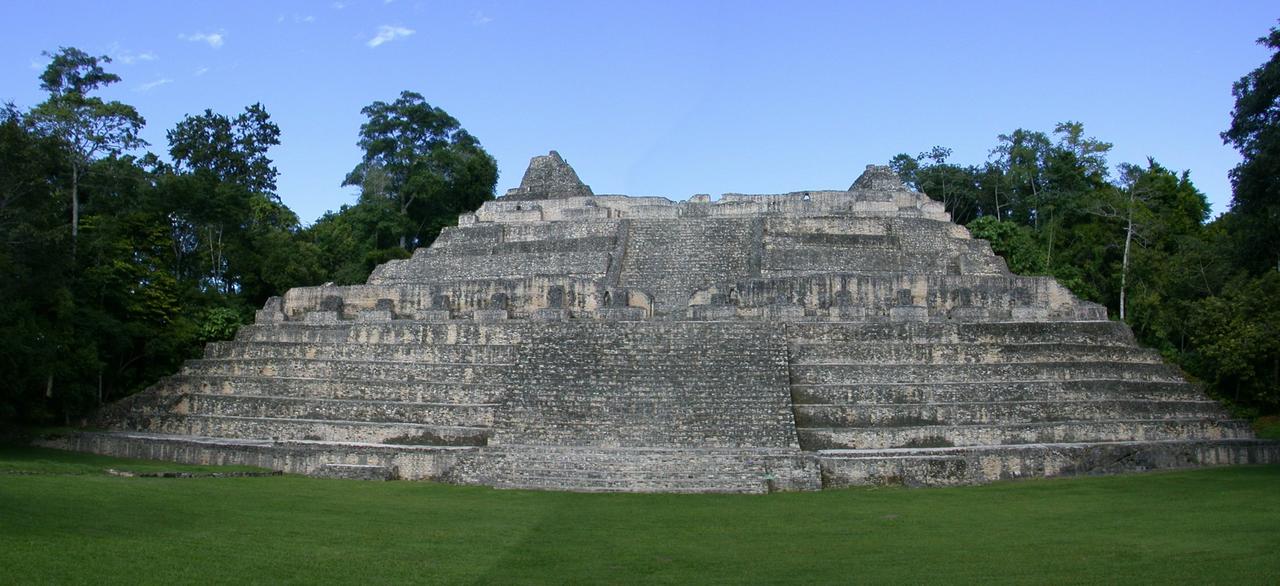
Photo: Devon Jones, CC BY-SA 3.0
Our pick for each kind of visit, with live dates and prices from GetYourGuide. Free cancellation on most.
Best for: First visit from San Ignacio
A guided day with transport over the long forest road and lunch at the site, so you can spend your energy on the ruins rather than on the driving.
Entry to Caracol is paid in cash at the visitor centre when you arrive, and there is no online ticket. The real question is how to get there: the site lies at the end of a long road through the Mountain Pine Ridge and the Chiquibul forest, close to the Guatemalan border, and most visitors come on a guided day trip.
The standard tour leaves San Ignacio early in the morning in a four-wheel-drive vehicle or minibus, spends three hours or so at the ruins with a licensed guide, and includes a packed or picnic lunch. Many versions add a stop on the way back at the Rio On Pools, the Rio Frio cave or a waterfall such as Big Rock Falls for a swim. Entry fees are sometimes included and sometimes paid on arrival, so check. A day trip from Belize City or the coast is possible but means many more hours in the vehicle.
Driving yourself is feasible in a sturdy hire car in the dry season, but ask locally about road conditions and security arrangements before setting off. For most first-time visitors the guided tour from San Ignacio is the sensible choice.
The main sight is Caana, a massive platform topped by palaces and three temples, rising 43 metres above the B Group plaza. Steep stairs climb through several levels of courtyards and small rooms where the royal family lived. From the summit you look over an unbroken forest canopy towards Guatemala, with no other building in sight.
At the foot of Caana, the B Group plaza is surrounded by temples and was one of the city's ceremonial centres. Its buildings are less restored than Caana, and copies and fragments of carved stelae and altars stand around the plazas, with explanatory signs. Look for the flat round altars set in the ground.
Live dates and prices from GetYourGuide. Free cancellation on most tickets.
A short walk west, the A Group was the earliest monumental centre. Its main pyramid, known for a wooden lintel of sapodilla wood still in place in its summit temple, faces a small plaza with an astronomical group used to mark the sun's path. Its ballcourt held the carved altar recording the victory over Tikal.
South of the main plazas, the South Acropolis is a raised group of residences where several elite tombs were excavated with their offerings. The tombs themselves are closed, but the climb gives a different view of Caana through the trees. Paths here are quieter and better for spotting birds.
Finish at the visitor centre near the car park, where a small exhibition explains the excavations, the causeways and the city's size. On the way, listen for howler monkeys in the canopy and look for toucans, parrots and ocellated turkeys in the clearings. Picnic tables here are where most tours serve lunch.
Caracol, known to the Maya as Uxwitza, was settled before 600 BC but rose to power in the Classic period. In AD 562 its ruler defeated Tikal, and in 631 it overcame Naranjo, beginning more than a century of prosperity in which the population may have passed 100,000. Causeways linked outlying groups to the centre across terraced fields. The city declined in the 9th century, and the last carved monument dates to AD 859. A logger named Rosa Mai reported the ruins in 1937, Linton Satterthwaite of the University of Pennsylvania documented them in the 1950s, and Arlen and Diane Chase have excavated every year since 1985, mapping the whole city with LiDAR in 2009.
From San Ignacio, take the Western Highway east to Georgeville or Santa Elena and turn south on the Chiquibul road into the Mountain Pine Ridge Forest Reserve. The road passes a forest station and runs through pine and then broadleaf forest; the last 16 km are paved, but other stretches can be rough or muddy after rain. The drive covers about 80 km and takes 2 to 2.5 hours, so a four-wheel-drive vehicle with a full tank is advisable, as there is no fuel on the way. There is a car park beside the visitor centre. No buses run to the site. Belize City's international airport is about 2.5 hours from San Ignacio.
Climb only on structures that are open and use the marked stairways, which are steep and can be slippery after rain. Do not touch or sit on carved stelae and altars, and stay on paths in the forest. Bring insect repellent, a hat, sunscreen, plenty of water and good shoes; there is nothing to buy at the site. Toilets are at the visitor centre. Tell someone your plans if driving, as phone coverage is poor.
Caracol is a full day out. Tours usually leave San Ignacio between 7 and 8 am and return in the late afternoon, and independent drivers should leave just as early, because the site closes in mid-afternoon and the road is slow. Crowds are never an issue: only a few thousand people visit each year, and you may have plazas to yourself.
The dry season, from about February to May, is best, with firm roads and clearer skies, though April and May are hot and humid. From June to November heavy rain can turn the road to mud and occasionally close it, and mosquitoes are worse. December and January are cooler but showers are common. At the site, climb Caana in the morning before the midday heat, then explore the shaded forest groups. Allow three hours at the ruins themselves.
The usual pairing is a swim on the way back at the Rio On Pools or a visit to the Rio Frio cave, both in the Mountain Pine Ridge. Back near San Ignacio, Xunantunich and Cahal Pech can fill a second day, and the ATM cave makes a demanding third.
| Hours | Daytime only, roughly morning to mid-afternoon; arrive by late morning to allow time |
|---|---|
| Closed | Open daily; heavy rain can make the access road impassable |
| Entry fee | Small entry fee, paid in cash at the visitor centre |
| Time needed | A full day from San Ignacio |
| Best time | Leave San Ignacio early; February to May for dry roads |
| Booking | Book a tour a day or two ahead; independent drivers pay at the gate |
| Access | Long drive on rough roads; forest paths, steep stairs on Caana, humid heat and mosquitoes |
| Getting there | About 2 to 2.5 hours by road from San Ignacio through the Mountain Pine Ridge |
| Civilisation | Maya |
| Elevation | 500 m above sea level |
| Visitors | 13 333 a year (2019) |
| Website | caracol.org |
| Checked | October 2026 |
Daytime only, roughly morning to mid-afternoon; arrive by late morning to allow time. Open daily; heavy rain can make the access road impassable.
Entry fee: Small entry fee, paid in cash at the visitor centre.
Allow A full day from San Ignacio for Caracol.
Book a tour a day or two ahead; independent drivers pay at the gate.
Yes. GetYourGuide lists 3 tickets and tours for Caracol, with live dates and prices and free cancellation on most of them.
Leave San Ignacio early; February to May for dry roads.
About 2 to 2.5 hours by road from San Ignacio through the Mountain Pine Ridge.
Long drive on rough roads; forest paths, steep stairs on Caana, humid heat and mosquitoes.
Worth it for a huge, little-visited Maya city deep in the forest, with a pyramid you can still climb and wildlife around you. Skip or shorten it if a long rough drive does not appeal; Xunantunich near San Ignacio gives a taste of Maya Belize in two hours.
San Ignacio, Belize
Xunantunich is a Maya ceremonial centre on a ridge above the Mopan River in western Belize, a kilometre from the…
6 tickets & tours
San Ignacio, Belize
Cahal Pech is a Maya hilltop palace complex on the edge of San Ignacio in western Belize, with 34 structures arranged…
No online ticket
San Ignacio, Belize
El Pilar is the largest Maya city in the Belize River area, a forested ruin straddling the border with Guatemala 12 km…
No online ticket

