Kekova Sunken City
9 km away
Kekova is an uninhabited island off the Lycian coast of southern Turkey whose northern shore holds the half-submerged…
5 tickets & tours
Ancient City · Greek · Turkey
Aperlae is a ruined Lycian harbour town on the coast of Antalya province, west of Kekova, whose lower quarter has slipped beneath the sea. It lived for about 1,300 years on the trade in purple dye from murex snails, and today its walls, churches, tombs and sunken houses can be explored freely on foot or with a snorkel.

There is nothing to buy for Aperlae: the site is unfenced, there is no gate and no entry fee, and no tour for Aperlae alone is sold online. The question is only how to get there.
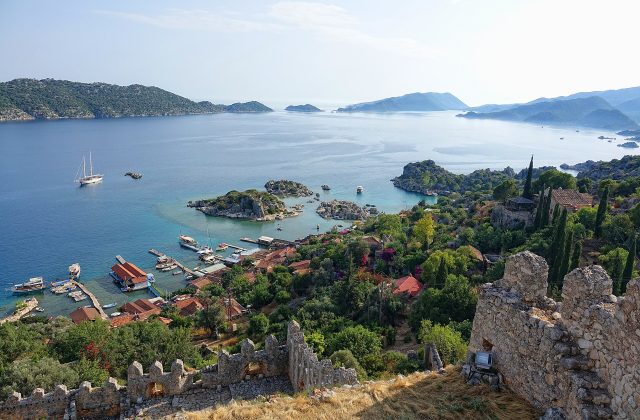
The most common way is by sea. Day boats from Kas and from the village of Ucagiz cruise around the Kekova area, passing the sunken ruins of Kekova island and the castle at Simena, and some of them stop in the bay at Aperlae for a swim. Ask before booking, as many routes do not include it. Sea kayak trips from Ucagiz also explore the coast, and a private boat can be hired in either village for a custom route. These trips include the boat and often lunch on board; time ashore is usually short.
The second way is on foot. The Lycian Way long-distance trail passes through the ruins, and a waymarked path of about an hour leads over the Sicak peninsula from the road near Kilinçli. Walking gives you time to see the walls and churches properly, and you can swim among the sunken houses.
The sensible plan is to walk in early with water and snorkel, or combine a Kekova boat trip with a stop here if your boat offers one.
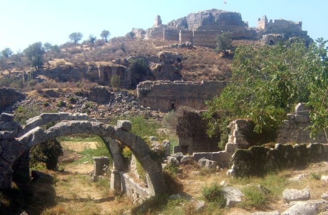
Coming down the path from the north, you meet the land walls first, built of large blocks and climbing the slope above the bay. They protected the upper town from the landward side and stand in places to a good height. Look for the gate where the path enters and the towers that once guarded it.
At the shore, the walls run straight into the sea, and below the surface you can see the outlines of houses, quays and streets. The lower town sank as the coast subsided over the centuries. On a calm day it is clearly visible from above with a mask, in water only one to three metres deep.
Live prices from GetYourGuide for tickets and tours that include this site. Free cancellation on most of them.
Inside the walls, the remains of several churches are scattered over the slope, part of the four known from the Byzantine town. Apses and wall stumps survive among the scrub. Their size and number show that the bishopric of Aperlae was rich in late antiquity, when it was an important seat under Myra.
With no river or spring nearby, the town relied on rainwater, and many cisterns are cut into the rock between the houses. Watch your step around them. Near the shore, mounds of crushed murex shells mark the dye works, and shells are visible in the mortar of the walls.
Outside the walls on the slopes, Lycian and Roman sarcophagi lie among the rocks, some with lids still in place and inscriptions on their sides. They belong to the long life of the town from the 4th century BC to the 7th century AD. From here the path continues along the coast towards Kekova.
Aperlae was founded between the late 4th and early 3rd century BC on a rugged bay of the Lycian coast. Farming was hard on this rocky land, but the town grew rich on royal purple, the costly dye extracted from murex snails, and its shells were even mixed into the building mortar. Aperlae headed a small union of towns that included Simena, Isinda and Apollonia. In the Byzantine period it was a bishopric with four churches. Around the end of the 7th century AD, as Arab raids made the coast unsafe, it was abandoned and never resettled. Part of the town later sank, and underwater surveys have mapped the drowned quarter.
Aperlae lies on the Sicak peninsula west of Kekova, in Kas district of Antalya province. From Kas, drive east on the coast road towards Demre, then turn off to Ucagiz; before reaching it, a side road leads to the hamlet of Kilinçli, where the path starts. The drive from Kas takes around 45 minutes, and the walk to the ruins about an hour each way. There is no public transport to the trailhead, so you need a car or a taxi. By sea, boats from Ucagiz take about 30 minutes. The nearest airports are Dalaman, about three hours west, and Antalya, about three hours east.
Do not move stones, take shells or remove any finds, including from the seabed: it is illegal to take antiquities out of Turkey. Snorkelling is fine, but scuba diving among ruins needs permission. Bring plenty of water, a hat, sturdy shoes and a snorkel; there are no shops, toilets or shade at the site. Beware of the open cisterns and loose stones, and tell someone your route if you walk alone.
Go early in the day. The path over the peninsula is exposed, and in summer the heat on the rocks becomes tiring well before noon. Morning light is also best for seeing the sunken houses through clear water, before the afternoon wind roughens the bay.
May, June, September and October are the ideal months, warm enough to swim but cool enough to walk. July and August are very hot, so walk only at dawn or come by boat. Boat trips from Kas and Ucagiz run mainly from April to October, and in winter few boats go out, though the site itself remains accessible on foot. Rain in winter makes the paths slippery. Visitor numbers are low all year; at most a few boats anchor in the bay at midday in high summer. Allow two to three hours on foot, including time to swim.
Ucagiz, a small fishing village with Lycian tombs, is the base for boats to Kekova island and its sunken ruins. Across the water, Simena has a castle and a tiny theatre above the harbour, and the Lycian sarcophagi of Teimiussa lie beside Ucagiz. Myra and its rock tombs are about 40 minutes east by road.
9 km away
Kekova is an uninhabited island off the Lycian coast of southern Turkey whose northern shore holds the half-submerged…
5 tickets & tours
21 km away
Myra is the ancient Lycian city on the edge of modern Demre, where a cliff face is carved with dozens of rock-cut tombs…
23 tickets & tours
55 km away
Tlos is one of the oldest cities of ancient Lycia, set on a rocky spur above the Xanthos valley about 40 km east of…
12 tickets & tours
| Hours | Unfenced site, accessible at any time; visit in daylight for the path and the boats |
|---|---|
| Closed | Open daily |
| Entry fee | Free |
| Time needed | 2 to 3 hours with the walk |
| Best time | Morning; May, June, September and October; calm sea for snorkelling |
| Booking | No ticket; book a boat in Kas or Ucagiz if you do not walk |
| Access | Rocky goat paths, loose stones, thorny scrub and no shade; not possible with wheelchairs or pushchairs |
| Getting there | Footpath of about an hour from the road near Kilinçli on the Sicak peninsula, or by boat from Ucagiz |
| Founded | 300 BC (c. 300 BC (late 4th-early 3rd century BC)) |
| Abandoned | AD 700 |
| Civilisation | Greek |
| Checked | October 2026 |
Unfenced site, accessible at any time; visit in daylight for the path and the boats. Open daily.
Entry fee: Free.
Allow 2 to 3 hours with the walk for Aperlae.
No ticket; book a boat in Kas or Ucagiz if you do not walk.
Yes. GetYourGuide sells tickets and guided tours whose route includes Aperlae; live prices are shown on this page.
Morning; May, June, September and October; calm sea for snorkelling.
Footpath of about an hour from the road near Kilinçli on the Sicak peninsula, or by boat from Ucagiz.
Rocky goat paths, loose stones, thorny scrub and no shade; not possible with wheelchairs or pushchairs.
Worth it for walkers and swimmers who want a half-sunken ancient town with no ticket office, no fence and very few people. Skip or shorten it if you need easy access, shade or facilities, since it is reached only by boat or a rough coastal path.
Aperlae dates from 300 BC (c. 300 BC (late 4th-early 3rd century BC)). It was abandoned in AD 700.
Kaş, Turkey
Patara was the main seaport of ancient Lycia and the meeting place of the Lycian League, on the Turkish coast near the…
No online ticket